
![]()
![]()
![]()
![]()
![]()
|
|
|
|
A "secondary" effect of Global Warming is a major rise in sea level as the glaciers in Greenland , East and West Antarctica, and the permafrost plus polar ice melt. The question is only how much of the water now stored in those glaciers will melt and how much will remain as permanent ice. Here are a series of maps showing the extent of flooding at both 60 Meters and 100 Meters sea level rise. (To the left the 60 M set is reached sub-level to the 100 M maps). Other authors have done (on net) 15 meters and in book on warming/ flooding there is a rough world 50 meter map. Below is a 75 meter estimate. MAPS AT 60 Meters Global Flooding MAPS at 100 Meters global flooding World 60 M in b & w for printing World 100 M in b & w for printing North America 60 M North America 100 M Asia- Australia 60 M Asia Australia 100 M South America 60 M South America 100 M (note Africa is only on world set) The 15 meter map is a minimal flooding from only melting the ice in East Antarctica. This scenario involves the volcanic disruption of that sheet by the known volcano under the glacial sheet becoming active by creating a liquid water (melt zone) layer below the ice that lubricates and moves the ice a VERY high rate -extremely rapid as glaciers go, flowing the glacier into the ocean. The quantity of water in that sheet would raise sea levels about 15 meters. I have checked that calculation and confirm it as correct. The 60 meter sea level rise set is based upon least expected global ice melt from global warming. This melts 60 % of Greenland (20 M global rise from melt) leaving the core 40 % which has not melted in "recent" geological time as observed in the core samples done by the Russian VOSTOK data set. The larger West Antarctic glacier was also melted 60% (20 M rise) and leaving 40 % of West Antarctic ice. All East Antarctic Ice (which has no residual old ice in any core set - it has all melted in the interglacial warm periods before) amounting to 15 m rise globally was melted. An additional 5 M of melt was taken for N Polar and Permafrost melt off but leaving half un melted. The 100 M flooding represents a best estimate of total melt down of all glacial ice. This is, unfortunately, a very credible scenario because of human intervention in the process, making this coming melt larger than past "ice age" warm periods which left beach records in the 60 M - 75 M range. It has been increased from earlier estimates (75 M) to include Permafrost (10 M) which was forgotten in earlier work and the greater ice content of Greenland (12 M) that we now know exists from deep core samples and extensive deep penetrating radar data work, and slightly increased Antarctic water storage estimates. (8M). All of these have also been corrected NOT to include the Glacial water already below sea level. There is a large quantity of glacial ice below sea level in both Greenland and Antarctica sheets. That will not contribute to sea level rise. Only ice above sea level "bench mark" has been used in the rise calculations. If we (in my opinion erroneously) used that we would get 120 M rise. I tend to worry about that as geological sea level beach marks are found at that 120 M level in the Paleocene. The results are similar enough for 100 M and 120 M that the 100 M still tells the catastrophic tale which is intended, and even 60 meters ( almost certainly an underestimate) is disastrous enough to cause alarm. HISTORICAL SEA LEVELS
Sea levels also follow glaciation patterns. As Glaciers form they tie up huge quantities of water, literally thousands of cubic kilometers of water, and sea levels fall. Conversely as glacial ice melts sea levels rise.
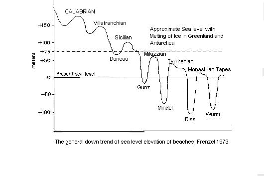
There are records contained in the beach levels of the world of 7 glacial periods, more than just the 5 glaciers for which we have good land records. If the East Antarctic sheet the smaller half, alone melts, that is about a 15 meters rise. A 15 meter rise perhaps could be handled, - dikes such as are used in Holland could be used to prevent flooding of low coastal cities. If the Antarctic sheet totally melts the sea level will rise about 42 meters. If both Antarctica and Greenland melted we would see about 75 meters rise! In the last cases this would be a potential catastrophe. The larger 42 to 75 meter rise would flood large areas including most major coastal cites like New York, Philadelphia. Washington DC, Miami (in fact Florida including Disney World virtually disappears totally!), San Diego, Los Angles, San Francisco, the inner California valleys flood, Seattle, Melbourne, Sidney, Tokyo, Hong Kong, all of Malaysia most of Java including Jakarta, Bombay, Calcutta, Capetown, most of the major cities in South America (Lima overall would escape), etc. Hundreds of millions of people, perhaps a billions of people would be displaced.
This hot cycle could cause a return of the great deserts of the past. The effect on arable land could be worse. At one time the US had a desert that stretched from Dakota to Arizona and was 2000 Km wide. Later the kilometer thick (3000 foot) petrified desert of the Navajo sandstone is a relic of another desert that covered most of what is now Arizona, Utah, New Mexico, and parts of Colorado and Nevada. The Sahara has been expanding in any case, and the Gobi could grow to massive proportions covering the grassy steps of mid central Asia and East Europe. Thus a major global warming can be almost as bad as an ice age.
|
|
Send mail to
Jhlawr@wmconnect.com with
questions or comments about this web site.
|